|
<< Click to Display Table of Contents >> 3E meteorological Data |
  
|
|
<< Click to Display Table of Contents >> 3E meteorological Data |
|
Since 2010, 3E transformed into a company in renewable energy technology and has launched the its solar data services since 2014.
3E data access is done through subscription on their SaaS platform Synaptiq.

3E's service provides a global coverage of TMY weather files based on their multi-year satellite-based irradiation timeseries.
The data has a with a spatial resolution 3 km, a temporal coverage from 1/2/2004 to H-40 and a temporal resolution of
- 5, 10, 15, 30 minutes,
- hourly,
- daily
- monthly.
The data parameters provided include:
- Global horizontal irradiance (GHI or GlobHor)
- Diffuse horizontal irradiance (DHI or DiffHor)
- Direct Normal Irradiance (DNI or BeamHor)
- Global Tilted Irradiance (GTI)
- Air temperature (Tamb)
- Wind Speed (Windvel) and Wind Direction
- Relative Humidity
- Total precipitation
- Snowfall

Modeling methodology (taken from 3E solar data Documentation)
The solar data by 3E are satellite-based irradiation data. The amount of solar radiation reaching the Earth's surface are measured using satellite
Satellite imagery
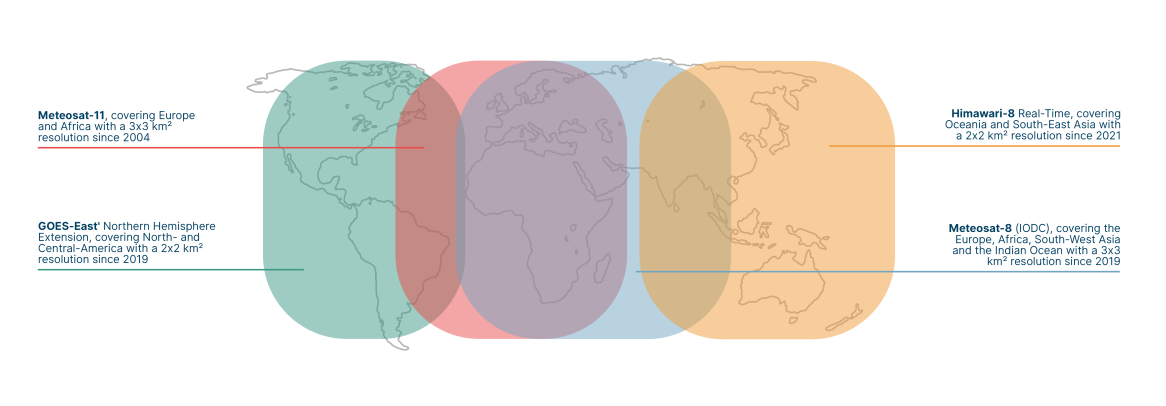
The cloud, radiation and precipitation properties are retrieved from the Spinning Enhanced Visible and Infrared Imager (SEVIRI) on board of four different geostationary weather satellites:
oMeteosat-11 (PRIME), covering Europe and Africa with a 3x3 km² resolution. Data is available as from 2004.
oMeteosat-8 (IODC), covering the Europe, Africa, South-West Asia and the Indian Ocean with a 3x3 km² resolution. Data is available as from 2019.
oGOES-East' Northern Hemisphere Extension, covering North- and Central-America with a 2x2 km² resolution. Data is available as from 2019
oHimawari-8 Real-Time, covering Oceania and South-East Asia with a 2x2 km² resolution. Data is available as from 2021.
The Cloud Physical Properties (CPP) algorithm is developed at KNMI to derive meteorological products from the Meteosat Second Generation (MSG) satellite. Based on the MSG-CPP, we identify the cloud, radiation & precipitation properties in 4 distinct steps:
First, cloud-free pixels are separated from cloud-contaminated & cloud-filled pixels with the GEO v2018 algorithms developed by the NWC SAF.
Second, the cloud optical and microphysical properties (i.e. top temperature, phase, optical thickness & particle size) are derived using algorithms developed in the CM SAF (Benas et al. 2017; Roebeling et al. 2006). The retrieval of most these properties relies on observations of solar backscattered radiation, and is thus limited to daytime (solar zenith angle smaller than 84°).
Third, the total surface solar irradiance and its direct & diffuse components are derived using the methods described in Greuell et al. 2013.
At last, the precipitation intensity is estimated based on the retrieved cloud properties during daytime (Roebeling & Holleman 2009) and based on statistical relationships with the observed infrared brightness temperatures (Brasjen et al. 2015).
A parallax correction corrects the derived irradiance properties for the relative position of both the satellite and the sun.
P50 or Pxx typical meteorological years (TMY) are created based on Cebecauer & Suri 2015, but different weighing actors are applied to tailor the creation of TMY's to the application of solar power simulations.