Reuniwatt data
Reuniwatt (Website) provides hourly solar radiation and weather data derived from 5 geostationary satellites, worldwide, in the form of time-series, TMY, and monthly averages files.
Data covers useful information for PVsyst:
- Global horizontal irradiance (GHI) [W/m2]
- Diffuse horizontal irradiance (DHI) [W/m2]
- Direct normal irradiance (DNI) [W/m2]
- Wind speed (WindVel) at 10 meters above ground [m/sec]
- Temperature (Tamb) at 2 meters above ground [deg.C]
- Relative humidity (RH) [%]
In the Reuniwatt irradiance dataset, please note that :
- The effect of far shadings from mountains at sunrise and sunset is not included, unless explicitly requested, which means that in mountainous regions an horizon mask can be further applied in the project area of PVsyst.
- The diffuse circumsolar radiation is included in the diffuse component, which means that the data is compatible with the use of the Perez-transposition model.
Reuniwatt is a paid service.
Details of the method
Reuniwatt retrieves data from 2011 from the following geostationary meteorological satellites : Meteosat-12, Meteosat-9, GOES-E, GOES-W, Himawari-9.
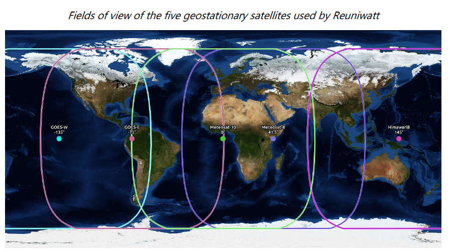
Figure 1: Fields of view of the geostationary satellites Reuniwatt works with
SunSat™ is an algorithm capable of producing GHI (or DNI) maps using both geostationary satellite visible channels images and several ancillary data such as elevation and clear sky irradiance.
Put together, the 5 satellites allow to compute GHI on the whole planet, except for the extreme latitudes. For locations within the field of view of several geostationary satellites, the one with the finest spatial resolution will systematically be preferred, given that the resolution is at its highest at the center of the field of view and gets progressively worse the further you move away from it.
Reuniwatt has developed internally its own real-time irradiance estimation method using raw images provided by geostationary meteorological satellites. Images from geostationary meteorological satellites’ broadband visible channel are used to retrieve solar irradiance at a world scale with a high spatial resolution going up to 0.5 km at nadir, with a sample time of 5-15 min. The general principle of such algorithms consists in comparing the reflectance observed at a given pixel with the reflectance from the same pixel under clear sky (cloud-free) conditions. A cloud index is computed from this difference. This cloud index is used as a linear attenuation factor of the simulated irradiance under clear sky. An internal clear-sky model is used during the post-processing chain. Processed data are recalibrated against ground stations.
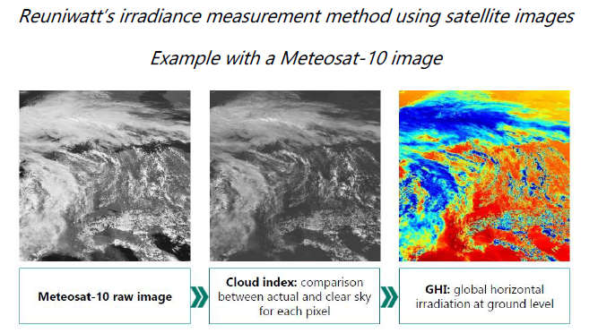
Figure 2: Reuniwatt’s irradiance estimation method using satellite images.